qui audet adipiscitur

←― those who dare, win ―→
Showing posts with label zambales. Show all posts

Wednesday, September 13, 2017


Growing up in San Narciso, Zambales,  I've heard stories after stories from our elders about a waterfall nestled in the mountains of Omaya but since means of transportation was still scarce at the time, no one,  (or at least, we didn't) dared to chase it.

Two decades later, the area was re-evaluated as a possible hiking destination in San Narciso. The local tourism office had conducted an ocular inspection just a month ago but details on how to get there and who to coordinate with is still a blur. Since then, numerous nature-seeking groups from different parts of Zambales have been flocking in. So did we.


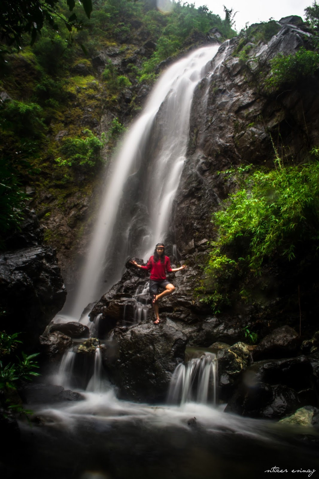
Name confusion. According to the locals and contrary to some posts circulating on Facebook, the name of the waterfall is Veto Falls and not Palacapac. Veto Falls is a three tier waterfall. Locals refer to them as V1, V2 and V3 respectively. Palacapac is a plateau above the three waterfalls. There's a small creek in it instead of a waterfall. The jump off point to Palacapac is at Omaya. 

Trail et.al . Trekking Vito Falls should take around one and a half to two hours only and not four hours as earlier posted. Jump off point is at Brgy. Paete , thirty minutes from San Narciso town proper, in a privately owned land by the Sabangan family. Although the jump off point is at Paete, Veto Falls is geographically a part of Omaya. 

First half of the trek is fairly easy with only a few ascends and steep descends. The trail is mostly sand, similar to what can be found in beaches. It's loose when dry and it gets too soft when wet, so mind your steps especially near the slopes.  Good thing, most part of the trail is covered by bolos and bamboos which you can cling on whenever you're unsure of your steps.  

Second half consists mostly of river trekking, rock and boulder hugging. The rocks are mossy, an indication that the trail's not used often, if not new. Despite being slippery, the boulders and cascades under towering trees are picturesque.


The main event. After almost two hours of non stop trekking, we reached Vito Falls. It's a plunge type waterfall with a small shallow but rocky basin. The safe enough to take a dip and enjoy the ice cold waters. 


Penny for my thoughts. Overall, the trail is beginner friendly but still can be challenging even for experienced trekkers. The local guides are still on constant search for a much safer trail but all in all, Veto Falls is definitely worth it. It is not something every true blooded Narcisenian should miss. Would I visit again? A hands down YES

(Sorry for the lack of photos. It was raining the entire time so we're soaked by the time we reached the falls.)


HOW TO GET THERE:

1. Ride a bus going to Iba/Sta.Cruz and get off at San Felipe town proper.

2. Ride a tricycle going to Paete (same route when going to Anghalo Falls). Drop by the Paete Brgy. Hall first to inform them of your intent to trek so they can assist you in getting guides and permission from the Sabangan family. (UPDATE: Here's the contact details of Paete Brgy. Capt. De Dios - 09493045099)

3. Get to the jump off point (Sabangan property). You'll pass by Mabato Elementary School. It is on the left side with an improvised bamboo gate. 


TIP BITS:

  • Do not trespass. Seek permission where its due.
  • Don't be hesitant to ask for guides. The trail can be tricky and who knows them better than the locals. 
  • Practice LNT (Leave No Trace). Be responsible for your trash.
  • Waterproof your belongings, just in case. 
  • Enjoy! ☺

###


Thursday, December 3, 2015


Vrksasana by the first level of Anghalo


With just a few hours from Manila, no doubt that Zambales is one of the sought-after alternative surfing spot to La Union or Siargao.When we say surfing in Zambales, the first thing that comes to mind is either Crystal Beach in San Narciso or Magic Left in San Antonio. During the recent years, however, tourists, foreigners and Filipinos alike, found their little surfing haven in San Felipe --- Liwliwa. Liwliwa has slowly making itself known to the surfing community in the Philippines. Though the waves here in Zambales, are beginner-friendly, they are seasonal. Don't fret yet. If the waves are too flat to surf, you can still swim in the friendly shores of Liwliwa, try paddle boarding and kayaking, OR it could be a perfect time to try something different. Grab some friends and go on a quick hike to Anghalo Falls! 


There weren't much narratives about this waterfall on the internet that's why we were so eager to go, before it gets commercialized. I first read about Anghalo Falls here in 2014. No pictures, just directions on how to go there, Curious-er and curious-er indeed. Finally, last summer we gave it a go. Just a heads up, not all locals are aware of this waterfall (or at least not aware what it is called) so make sure you really know where you're going.  Luckily for us, our Manong trike know about the waterfalls. Unfortunately, he refused to take us there. He said that the waterfall dries up during summer and that we should just go back on rainy season.


Second visit to Anghalo. This time with friends.

Fast forwarding to the rainy season and with all the thunderstorms that hit the province, its about time to pursue Anghalo once again. There are two trails to Anghalo, one is marked by a white flag on the way to the Groto, and the other one is by the stream along the road. We took the trail by the stream.   The trail by the white flag was more popular and according to the locals, its shorter, wider and easier.


We were not disappointed, well, almost. Having no idea that the falls was that popular already (at least to the locals), we confidently went on a saturday and much to our surprise, it was overcrowded. I did not even dare to take a picture of the falls. 


On out third attempt, we came on a weekday because, let's face it, it was quite a shame not to enjoy the scenery as it is. As soon as a heard the gushing waters, I was crossing my fingers and chanting to myself "I hope there weren't much people." I guess I chanted the phrase too much that we were the only ones there. Weee, unlimited photo ops! 
                                                                     
Here's how the first level looks like in real life, minus the long exposure.

In case you're wondering where Anghalo falls got its name, legend has it this three-leveled falls was formed when the giant Angalo (or Anghalo) stepped on it when he was searching for his wife, Aran. Perhaps this falls was one of the series of giant footprints scattered in the country  believed to have made by Angalo. 


The first level of Anghalo is one pretty dramatic waterfall with water gushing at one end and little streams lovely flowing over a boulder. It's pool was just right for its height. What surprised me though is that of all the waterfalls that I have seen, Anghalo has the warmest waters. Not even close to cold and I can't figure out why. Haha. Anyhow, the water's deep on both ends but shallow on the center. You can walk straight to the boulder. Like we did above. ↑↑↑

Second level of Anghalo Falls.
To reach the second level, you need to follow the trail found on the left side facing the waterfalls. It's narrow and a bit steep so be extra careful as is it just beside a cliff. Don't worry its just a short trail. Upon reaching the top of the first level, you need to do a short trek to the second waterfall. There's no definite trail here, just remember to stay on the sides. Trust your instincts, whatever would make the river trekking easier.

Although it doesn't show in the pictures, the second level is much higher than the first, has a stronger current and a narrower  but deeper pool. The water's less warm here, I must say. Haha. The second level is a diving spot. Climb the boulder on the left side facing the waterfall. Be cautious, though. The boulder's steep and slippery, I couldn't get high enough to dive. The locals said that there was a recent death here because of diving so be extra careful.


If you want to take a break from surfing or paddle boarding, or want to go on a simple weekend picnic with friends or family, or just tired of the usual swimming pool scenario, or just simple happen to be around the area, then I highly suggest you visit this beauty. Literally chill hike and voilà


We left a cairn for free spirited souls like ours, if its still there, hope you can add more. ☺

TIP BITS:

1. If you'll take the trail by the stream, don't forget to wear long sleeves to protect your skin from being scratched by the tall grasses and insect bites and be sure to have your own guide since this trail is a bit tricky. (Thank you Cousin Irma for guiding me and my friends. )

2. Two to three hours won't ever be enough to enjoy this beauty so better start exploring in the morning. :)

3. Swim/dive at your own risk. There are no life guards nor life vests for rent, no one to save you but yourself. 

4. Leave No Trace. The place is yet to be managed by the local tourist office so there are no entrance or environmental fees, no one to watch over the place and no one to take your garbage for you so please be responsible. ###

Wednesday, November 4, 2015


 The original plan was Mt. Pundaquit - Anawangin traverse and a side trip to Pundaquit falls but since its summer the trail and falls were dry as hell. Also, we were an hour behind schedule so we just did a quickie hike to, as the locals call it, Mt. Dionisio. It seems to me though that the so called mountain is a part of Mt. Pundaquit. 


If you'll ask me, its more of  a hill than of a mountain but it's high enough to see most of Barangay Pundaquit. What made this hike exciting was the fact that there wasn't a real trail or path to follow. Just go up and onward, don't trip, don't fall.  We came across fallen trees, rocks and dried bushes. Be extra careful with the dried grasses, particularly the piled ones. They may look safe and fluffy but sometimes there are holes and huge rocks hiding underneath. Trust me.  I fell once or twice into a knee-deep hole, lost my balance, threw myself to another pile of dried grass for safety just to realize that its a huge sharp rock. Tadah! Instant bruises!


Anyhooow, like any other mountains, this hill has its own charm, too. Although our guides didn't take us to the summit,  the view from where we reached was just as picturesque. The view was a splash of color. Brown from the rocks and clay, blue from the sky and sea, and a mix of orange and greens from the grasses. Also, we hiked during the golden hour which added a nice warm tone to the view.


Cute little ridge, thought that perhaps this is the younger brother of Tarak Ridge in Mariveles, Bataan. I haven't been there but based on the pictures they somehow resemble each other. Or maybe not? :p

Unleashing the path finders in us, us girls trailed away from the boys as they obediently followed our guides. The others still in sight, we wandered off and looked for higher grounds. We're already by the cliff and piles of dried grasses got trickier and trickier by each step, we found this... 


...this lovely Batanes-like scenery. We were all awestruck. Lovely, just lovely. We took turns in taking pictures, relaxed by the cliff, waving to the boatmen and tourists from time to time. Haha. I bet they felt how triumphant we were.


Sunburn? What sunburn?  We couldn't care less. This was priceless. To be honest. I thought I've seen everything that Pundaquit and the coves can offer . Apparently, I haven't. As much as we want to stay a bit longer, our skins were already starting to hurt as well as our stomachs. They're screaming lunch! So we descended.


With a few beers for the boys, endless pusoy dos and some power naps for the girls , we got by until sunset. Living in a coastal town, sunset is something very familiar to us but it seems that we will never grew old of watching it. As for me, it has a soothing and comforting effect. Sooooo, that's just about it. From the humble morning hike to worth-the-wait sunset. Until next time. Hasta la próxima

(Thank you cousin Jenny for my awesome solo pictures and to Aunt Emy for our group pictures.)


Monday, September 7, 2015


Instead of celebrating my birthday the usual way, I decided to do something worthwhile. I've been in love with the beach ever since I can remember and it's about time that I return the favor. With the help of LGU San Narciso, I was able to participate in the International Coastal Cleanup last September 2014 and I'm very pleased to say that Zambales had the most number of volunteers for ICC 2104. Kudos to all the organizers and volunteers!

Here are a few snapshots of the event, taken by yours truly. 


To know more about ICC and how you can volunteer, click the link below.


Hope to see you all soon in this years ICC. :)


Wednesday, March 18, 2015


San Antonio, Zambales, home to the lovely coves: Anawangin, Talisayin, Nagsasa, and Silaungin, is just approximately 4-5 hours away from the Metro and is just 30 minutes away from my hometown San Narciso. Whenever people learn that I'm from Zambales I'm often asked if I have been to Anawangin. With much shame and regret I would answer, "No, I haven't". Over the past years, Anawangin and the other coves have gained popularity and became one of the top picks for quick getaways. I intended to know why so I finally gave in.

What started as a drunken conversation eventually turned into an impulsive getaway. While some of us were still terribly hungover, we packed the leftovers from the night's party and hit the road. We didn't have any concrete plans until we're in Pundaquit. Lucky enough, one of my cousins have a friend there who happens to have boat rentals. 


After some discussions and more haggling, we finally came up with an itinerary. Since we went on a sunday and some of us have works the following day, we opted for just a day tour. (Funny that I have to use the term "tour". I sounded like a tourist for a moment there. Hmm. )


Le Cousins at Capones Island.


First off, Capones Island. What others didn't know is that there are two entry points to the island. If you want to see the old lighthouse, just tell your boatman to anchor your boat on that side of the island. Otherwise, they would take you to the opposite side. Just like what happened to us. Another lesson learned. 


This side of the island wasn't that bad, though. It's a long stretch of white sand beach. The sand's not as powdery as the other islands in the country but we didn't mind. The patterns of the wall caught my eye. Mix of browns, greens and some grays, very earthy. On both ends of the island, you'll see an array of rocks in all sizes imaginable. That would've been my spot if we stayed longer. Sadly, we only stayed for half an hour.


Touch down Anawangin! 

Alright, first impressions. The waters looked more inviting to me than that of Nagsasa and Talisayin. Read my post about Talisayin Cove here.  It's a lot smaller compared to the other coves, though. I finally understood why many people refer to this cove as "tent city". I expected it to be crowded but I didn't expect it to be this crowded. 


Carefree weekends, Bro! 


To stray away from the crowd, we went to a quick hike to the view deck. There are no guides for this but  worry not,  the trail's easy. No diverging paths whatsoever. Just follow the path until you reach the top. From here you'll see the entirety of Anawangin, it's shore and the lagoon opposite to it. Mountain, beach, lagoon and agoo trees, I just love the contrast of colors, very vivid. 
The unknown cove on the opposite side of Anawangin


After admiring the view and some photo ops, we started the descent. As soon as we reached our table, we had lunch and of course, some more beer. Ha-ha. Though we only stayed for the afternoon,  I'm guessing that an overnight camping would have been as fun. :)

P.S terrible hangover + tipsiness + 30 mins boat ride = Not a good idea. 
TIP BITS: 

1. Boat rides can be very pricey since the cove has gone overwhelmingly popular to tourists. If you want to save, better be in groups, the more the cheaper. The locals are friendly so feel free to haggle but please, please,  do it humbly and politely. I've seen tourists shouting and even threatening the locals just to get a discount. Tsk.

2. There are small stores in the cove but commodities are sold in much higher prices. Better yet,  bring and cook your own food. Water and coolers with ice are already included in some boat packages. Grillers are free to use, too. 

3. To save more, you can bring your own tent or hammock so you won't need to rent one. Tent rentals costs approximately 300 Php per night. 

4. If you want to push your getaway further, try trekking to the cove via Mt. Pundaquit. Guides are available at the jump off point. If you want to trek but still want to go island hopping, no problemo. Trek your way to the cove then  by boat, take a side trip to the islands on your way back to Pundaquit. :)


Photo Credits to Aunt Emy for our group pictures and Cousin Irma for my solo pictures.

Saturday, February 7, 2015


A year ago, I was invited to an all-expense-paid day tour to the bigger yet lesser-known brother of Anawagin Cove ---Talisayen Cove. According to one of the locals, the cove derived its name from talisay  (or commonly referred to as lugo tree or umbrella tree), which used to be abundant in the area. It took us more or less an hour of boat ride going to this cove as it's farther from the shores of Pundaquit. 


The features of Talisayen is very similar to that of the other coves of San Antonio: clean and calm waters, light gray sand, and the plethora of agoo trees.  Talisayen doesn't have a lagoon unlike Anawangin or waterfalls unlike Nagsasa, but it does have a wider shoreline. Perhaps twice as wide as Anawangin. 


The rocky side of the cove, en route to the view deck. Nice spot to have a pictorial. He-he. From here you'll reach the view deck in about five minutes as the trail is just short and easy. 


Compared to Anawagin and Nagsasa cove, Talisayen have a concrete view deck. It's like a huge balcony atop the hill. This is a double-edged sword, though. With the balcony, there's no need to worry if you'll slip or if you're standing too close to the cliff. On the other hand, it also altered the natural structure of the hill.  Either way, the azure sea was truly a sight to behold. 

(c) Shella Limos
If you're trying to relax and avoid the crowd then this is the cove for you. What makes it favorable over the other coves is its quietude. It's not as commercialized and crowded as the others. Also, if you're not into camping, cottages are available for rent. 

Just a friendly reminder, the waves are stronger in the afternoon. So if anyone in your group is faint-hearted, I suggest you guys leave earlier when the sea's calmer. Remember, the cove is an hour or so away from Pundaquit, so it'll be one hella of a boat ride.


Wednesday, February 4, 2015


Way back in highschool, we were asked to identify one historical place in Zambales, visit the site, make a presentation and paper about it as a part of our final requirement in History. This shouldn't be a problem since there are a lot of historical places in the province that are accessible, plus written sources are readily available. However, our group wanted to take it to the next level, so we rooted for Mt. Pinatubo. 

Geographically speaking, Mt. Pinatubo is situated at Botolan, Zambales, which is just about an hour away from our hometown, San Narciso. Going to the actual site from Botolan proper is another story. We were told that the trail was only known to the Aetas and that it would take us days to reach the crater. With that being said, we opted for our Plan B. Not a bad choice actually, we still got a high grade. Hehe

Anyhow, it was not until 2013, when I resided in Clark, Pampaga,  that I learned about the alternative route to Mt. Pinatubo --- via Sta. Juliana, Capas, Tarlac. The route is safer and easier that the trek can be done in a day. I told myself I have to go ASAP while I'm still not that busy. I intended to travel DIY style, as always,  but this time it turned out to be more expensive to travel solo, so I searched for the cheapest public tour online. 


Gladly, I found TriPinas!  They were offering the cheapest All-in Pinatubo public tour so I booked immediately. My transaction with them was uber fast and hassle-free, I must say. 

I told my father about my plan and he asked if he can tag along. Though I wasn't that sure if he is still fit to do so, it's not everyday that he would volunteer on trips like that so I agreed without hesitations. Perfect timing as this served as our Father-Daughter Post-Valentines date. I'm not loveless, mind you, but I just wanted to approach this day differently, meaning, to stray away from all the cheesiness, or bitterness, if I may add, that this day usually brings. Ergo, yes to the outdoors! :)

(Grand) Canyon de Pinatubo? Look how happy he is. :)


Ms. Ann herself,  the head/founder of TriPinas, was our tour coordinator that day. Everything was organized and in accordance to the itinerary. Kudos!


Considered as a minor hike, the trail's easy and beginner-friendly. Perfect for those who want to try hiking or trekking for the first time. We used the old way so it took us more or less two hours to reach the crater. The first part of the trail was a lahar (lava) area so almost everything's just dry and hot, hot, hot. For me, the scorching sun had to be the biggest hurdle in this terrain, as there were no trees or huge rocks to seek shade to. Good thing there were some small stream crossings which helped us cool down a bit. As we passed through some lush vegetation, we knew that we're just a few steps away from the crater. 


I wasn't expecting to be this chilly here, so hello for a sunbath! :)

Upon reaching the crater, Ms. Ann gave a quick lecture about the history of Mt. Pinatubo. She also explained why the color of crater lake differ from time to time. Apparently, we were eluded by the blue green algae, the ones responsible for the turquoise color of the lake. The lake was somewhere between dark green to blue green when we were there.  Nonetheless, it's just as rewarding. 

The Majestic Mt. Pinatubo, February 2014.


Adieu, Your Majesty. Hope to see you soon in turquoise. :)


(All photos were taken by yours truly. Self portraits were shot with the use of an improvised tripod.)

Saturday, January 31, 2015


With a 7am-10pm work schedule, hours of talking non-stop, you can just guess how bored and drained I was. I felt the need to go go somewhere quiet, peaceful, and just isolate myself from all the hustle and bustle. Yes, I desperately needed a break! 

In came Seollal (Lunar New Year), one of the few (emphasis on few) holidays that our company recognizes, and thus my first solo camping trip. It's almost a year since then. 


I went on a friday so I got the whole resort to myself. The stillness of the surrounding was de-stressing in itself. I was finally able to relax without anyone nagging me, plus I got to pitch my tent whenever I want. Hehe. By noon the following day, this side of the island already resembled a tent city. 


I went solo but was I really alone? No, I wasn't. Some of the guests were really friendly and easy to get along with. We shared stories about anything under the sun. Not bad for a first timer, eh? 


Before I went camping, a  Korean friend told me that watching the day break on Seollal will bring you luck the entire year. Good thing, I woke up just in time even though I lacked sleep for days. Ha-ha.


Right then and there, I fell in love with the sunrise that I almost forgot the take a picture.  I have seen a hundred sunrises in this lifetime but this was different. The way the cloud burst while the sun slowly peeked through the mountain, it was overwhelming. I can't even describe it enough. 

So, did the Seollal sunrise bring me luck? I believe so. :)

__________________________

How to get to Magalawa Island:

(1) Ride a bus/UV express bound to Iba/Sta. Cruz and ask the conductor or driver to drop you off at Radio Veritas in Palauig. If there are no direct trips to Iba from your area, you may ride a bus/UV express bound to Olongapo. From there, ride another bus bound to Iba or Sta. Cruz.

(2) From the drop off point, ride a tricycle going to the port. Be sure to tell Manong driver  which resort you'll be staying at as there are different pick up points for the resorts. 

(3) While enjoying the bumpy trike ride, contact the resort's boatman, so he can pick you up at the port.